")
")

Ph.D. candidate Katarina Zailac, along with her mentor Assoc. Prof. Dr. Josip Stipčević and colleagues Acad. Igor Vlahović and Assoc. Prof. Dr. Bojan Matoš from RGNF, published in the journal Solid Earth (Q2) the reference seismic crustal model, which, as far as we know, is the first comprehensive model of the crust for the broader area of the Dinarides and the Pannonian Basin. The model was built using the known data on the crust structure, both in the Dinarides and in the Pannonian Basin. Both the scientific article and the model itself are available in open access, and the digital form of the model enables very simple usage in future seismic research, for example, in assessement of the seismic hazard or as an input model for the simulations. The article is part of the research conducted within the DuFAULT project financed by the Croatian Science Foundation and the leadership of Assoc. Prof. Dr. Josip Stipčević.
An advancement compared to one-dimensional seismic models (where Earth is depicted as a series of layers with uniform properties throughout the defined area) is that in the new model, seismic parameters (seismic wave velocity and density) vary with depth and within the defined layer. Additionally, the Mohorovičić discontinuity is not a flat plane; its depth varies at different locations. For instance, in the Pannonian Basin area, the Earth's crust is much thinner, and the Mohorovičić discontinuity lies at a depth of about 20 km, while in the Dinarides area, its depth extends deeper than 45 km, especially in the southern part of the Dinarides.
In addition to the variable depth of the Mohorovičić discontinuity, the new model also pays attention to sediments in the Pannonian Basin through which seismic waves propagate and the carbonate layer in the Dinarides region. In "softer" sediments, seismic waves travel significantly slower compared to hard rock, while the carbonate layer in some places reaches a thickness of more than 10 km, which is substantial for Earth structure research. Consequently, when studying wave propagation through the Earth, wave rays are no longer approximated as straight lines but as curved paths, which is a significant improvement over one-dimensional models and much closer to reality.
This seismic crustal model in its current state can still be further upgraded and improved with new data. In some areas, data coverage was not optimal, resulting in less precision in the model for such areas. Further research is demanding and costly, but we hope that this initial version of the model will encourage even more research in this small yet geologically very complex and interesting area.
Zailac, K., Matoš, B., Vlahović, I., Stipčević, J. (2023): Reference seismic crustal model of the Dinarides, Solid Earth 14 (11), 1197–1220. https://doi.org/10.5194/se-14-1197-2023
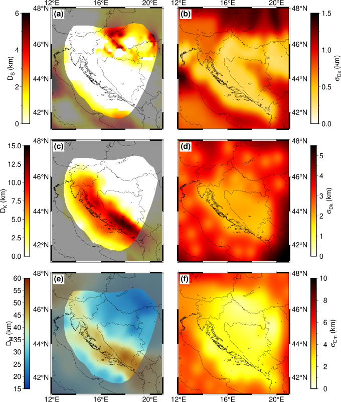
The left column displays the depth of sediment (DS), depth of carbonate (DK), and depth of the Mohorovičić discontinuity (DM, i.e., thickness of Earth's crust), along with their corresponding uncertainties.